Active filter
- Search for "Lower"
- Sort by "Best results"
 - Eifel Tourismus GmbH AR-shapefruit AG, © Eifel Tourismus GmbH AR-shapefruit AG")

Eisenschmitt fountain
Eisenschmitt
The Eisenschmitter fountain stands in front of the church and is known beyond the region. It was designed and created by the artist Johann Baptist Lenz from Oberkail.
More information

Prangerkreuz Dreis
Dreis
Diagonally opposite the gallows cross, on the 10. 5 km long Dreiser Kreuze-Weg at Rosenplatz is the Pangerkreuz from the second half of the 17th century (station 2).
More information
St. Vincentius Kirche Heidweiler
Heidweiler
The worth seeing St. Vincentius church from 1416 is one of the oldest churches in Wittlicher Land.
More information
Gemünden maar nature pool
Daun
The Gemündener Maar outdoor pool area invites you to swim and have fun.
More information
Gemündener Maar
Daun
The Gemünden maar is lined up along a fissure running SE to NW. About 20,000 to 30,000 years ago they erupted and Gemünden Maar lake was formed.
More information

Mosbrucher Weiher
Mosbruch
Mosbrucher Pond The Mosbrucher pond is framed by agriculturally used area of the neighbouring communities. In the areas of undisturbed marshland development, the peat thickness is up to 6 metres, on top of which a varied mosaic of different marshland communities can be found…
More information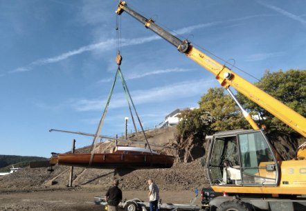
Kranservice
RurseeZeit | Heimbach
With our mobile crane, we can bring your boat into the water for you conveniently, safely and on time. Optionally, we can also erect the mast for you. Of course, we are also happy to take care of the entire slipping process for you, including transportation, mast positioning/placement and hauling to the jetty…
More information